RedSky Weather Radar Quick Start
Initial Screen
RedSky's initial screen shows a map of the United States with many blue dots on it.
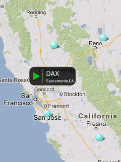
Each blue dot represents a National Weather Service Radar site. Touch a blue dot to open up a small info window describing the site. Touch the green play arrow icon to load available radar data for that site. A long press forces the imageset to reload.
The radars are overlayed on a standard Google Map View:

- Drag your finger to move around
- Double-tap or pinch the screen to zoom in
- Reverse pinch to zoom out
- Tap a radar site (blue dot) to select it. Press the filmstrip icon to load the animation.
- A long press on either load button (US mosaic or filmstrip) forces a reload
Controls
 Toggles map and satellite views
 Toggles your current location
 Toggles National Mosaic Image
 Activates user preferences.
Weather Products
RedSky Weather Radar supports 7 different National Weather Service radar products including:
- NOR (124 NM Reflectivity)
- NOZ (248 NM Reflectivity)
- NCR (Composite Reflectivity)
- N1P (1 Hour Precipitation)
- NOS (Storm Relative Velocity)
- NOV (Velocity)
- NTP (Storm Total Precipitation)
Select the radar product by touching the radar product label in RedSky's main title bar.
Preferences
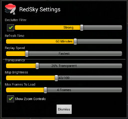
The preferences screen is largely self-explanatory.

- Declutter filter attempts to remove radar noise from the image frames. It slows down loading slightly but can significantly improve the results.
- Refresh time controls the length of time between reloading.
- Replay speed controls how fast the animations will play.
- Transparency controls how the transparency of the animations.
- Map Brightness controls how dark/light the underlying map will be. Certain radar features may be more visible when the map is darkened.
- Max Frames to Load controls how many frames will be loaded. Images are cached to reduce bandwidth.
- Show Zoom Controls toggles the map's built-in zoom controls.
- Tap the title logo to see the about screen
Miscellaneous
RedSky requires Coarse Location, Internet and Network State permissions.
Contact us: redsky@tinfoilninja.com